
California features a plethora of reservoirs that sustain the water supply around the state.
The 7 largest water reservoirs are Shasta Lake, Lake Oroville, Trinity Lake, New Melones Lake, San Luis Reservoir, and Don Pedro Reservoir.
These reservoirs were all built to provide water for the state’s rapidly-growing population and support its vital agricultural industry.
Each of these bodies of water has unique characteristics that make them stand out from the rest, including their size and depth, the number of recreational opportunities they offer, and their ability to provide water for a wide variety of uses.
Whether it’s supplying water to homes and businesses or supporting important agricultural activities like growing crops and raising livestock, California’s reservoirs play a vital role in the state’s economy and way of life.
What Is a Reservoir?
A reservoir is a large body of water that is created and stored behind man-made dams.
These artificial structures are typically built to collect rainwater or runoff from melting snow, providing essential water supplies for use in homes, businesses, and various other areas of the economy.
Some reservoirs are also used for recreational purposes, such as boating, fishing, and swimming.
California is home to some of the largest reservoirs in the United States.
These massive bodies of water not only provide water for a variety of uses but also support vital agricultural activities and offer recreational opportunities for residents and visitors alike.
Is a Reservoir a Lake?
Most reservoirs are created by damming a river to redirect its flow into a man-made basin.
This process often alters the natural environment, flooding areas that were once dry land.
In some cases, such as with Shasta Lake, the reservoir is actually larger than the pre-existing lake that it was created from. In other cases, such as with Lake Oroville, the reservoir is smaller than the natural lake that it was created from.
The 7 Largest Water Reservoirs in California
Shasta Lake: California’s Largest Reservoir

- Location: Shasta-Trinity National Forest, Shasta County, California.
- Coordinates: 40.7602°N 122.37190°W
- Volume (acre-feet): 4,552,000
- Outflow: Sacramento River
Shasta Lake is the largest reservoir in California and the centerpiece of the state’s massive water infrastructure system.
The lake is located in northern California, in the Shasta-Trinity National Forest. It is fed by the Sacramento River and has a capacity of 4.5 million acre-feet (5.6 km3).
The lake was formed in 1944 when Shasta Dam was completed as part of the Central Valley Project, a massive public works project that seeks to provide reliable water supplies for California’s rapidly-growing population.
Today, Shasta Lake is a popular recreational destination, offering miles of stunning shoreline and numerous opportunities for fishing, boating, and camping.
It also plays an important role in California’s water supply system, providing water for irrigation, domestic use, and hydroelectric power generation.
2. Lake Oroville
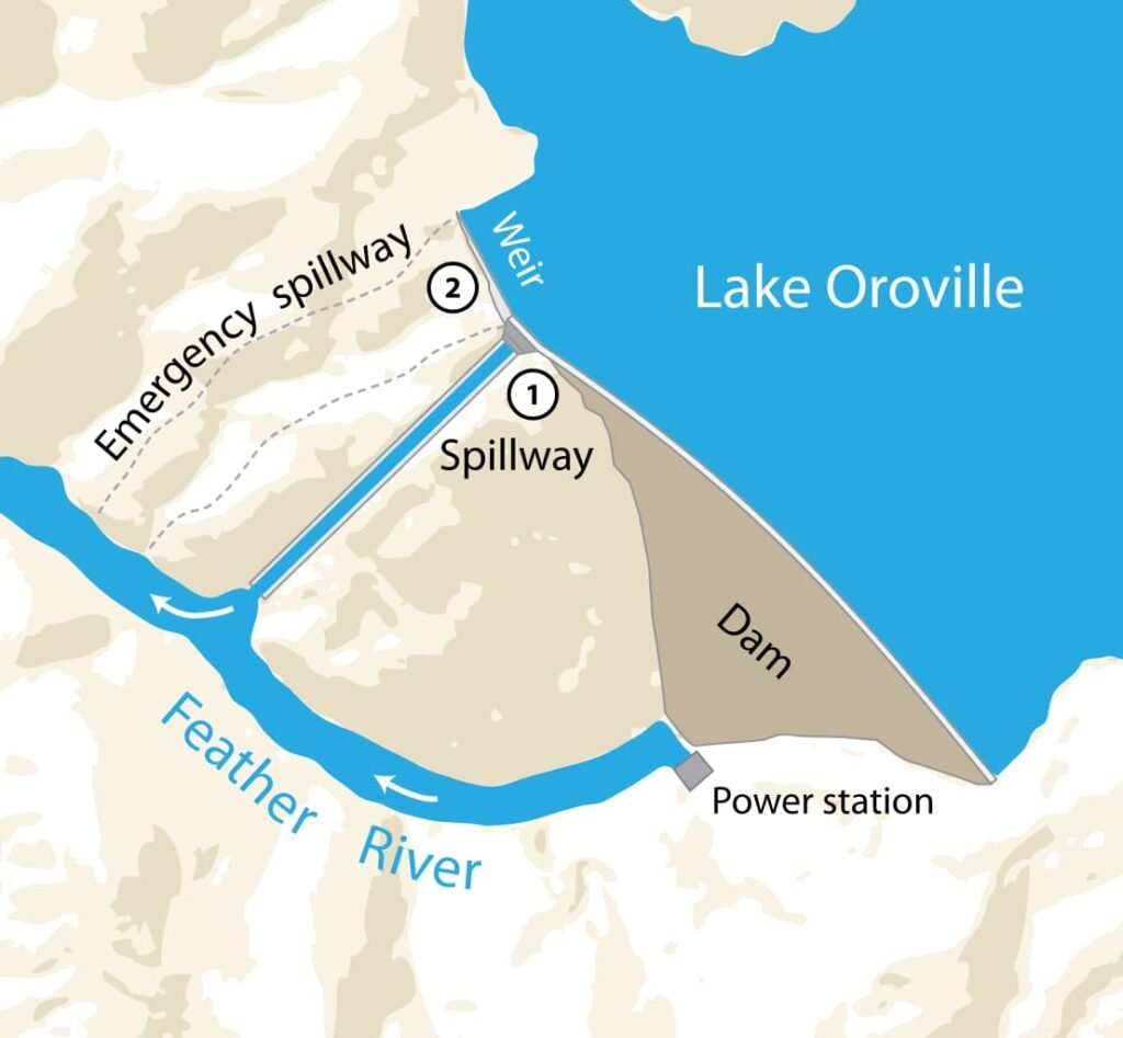
- Location: Oroville East, Butte County, California.
- Coordinates: 39°32′14″N 121°29′00″W
- Volume (acre-feet): 3,537,577
- Outflow: Feather River
Lake Oroville is the second-largest reservoir in California, with a capacity of 3.5 million acre-feet (4.4 km3). It is located in the Sierra Nevada foothills about 70 miles (110 km) north of Sacramento.
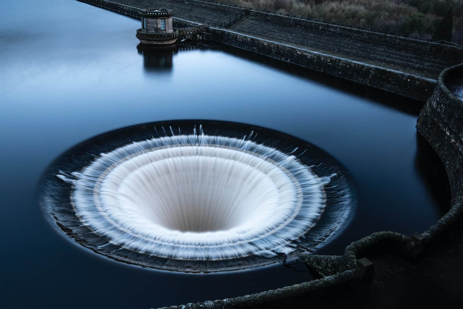
Lake Oroville was created in 1968 by the construction of the Oroville Dam, which is the tallest dam in the United States.
The State Water Project distributes water from Lake Oroville to households, farms, and enterprises across the San Francisco Bay region, the San Joaquin Valley, and Southern California.
The reservoir is a popular recreation destination, with over 2 million visitors each year. It offers a variety of activities, including camping, horseback riding, powerboating, water-skiing, and fishing.
In addition, the project’s Oroville facilities enable flood management and smog-free electric power generation.
3. Trinity Lake

- Location: Trinity County, California
- Coordinates: 40°51′36″N 122°43′24″W
- Volume (acre-feet): 2,448,000
- Outflow: Trinity River
Trinity Lake, with a capacity of 2.5 million acre-feet (3.1 km3), is located in the Trinity Alps of Northern California, about 60 miles (97 km) west of Redding.
Trinity Dam was built in 1961 and was a success since it not only gave water to California’s thirsty Central Valley but also produced hydroelectric power for the surrounding communities.
The reservoir was ultimately filled with water in 1963, and the project was completed. Trinity Lake is currently the third biggest lake in California’s sunny state.
The reservoir is a popular recreation destination, with over 1 million visitors each year. It offers excellent hiking opportunities, as well as a diverse range of wildlife, horseback riding, and river rafting.
4. New Melones Lake

- Location: Calaveras County, California.
- Coordinates: 37.9990°N 120.5212°W
- Volume (acre-feet): 2,400,000
- Outflow: Stanislaus River
With a volume of 2.4 million acre-feet, New Melones Lake is California’s fourth-largest reservoir (3.0 km3). It is located in the Central Sierra Foothills, about 50 miles (80 km) east of Modesto.
New Melones Lake was created in 1978 by the construction of the New Melones Dam, which transformed a valley into a reservoir that spans over 12 miles (19 km) long and 2 miles (3.2 km) wide.
New Melones Lake is a vital source of water for the state’s agricultural industry and is used to support about 100,000 acres (40,470 hectares) of land in the Central Valley.
The reservoir also provides flood control for nearby communities and supports a variety of recreational activities, Enjoy pet-friendly tent and RV camping, miles of hiking and mountain biking trails, fishing, swimming, and boat rentals.
5. San Luis Reservoir

- Location: Merced County, California.
- Coordinates: 37.9990°N 120.5212°W
- Volume (acre-feet): 2,041,000
- Outflow: California Aqueduct
The San Luis Reservoir is the fifth-largest reservoir in California, with a capacity of 2,041,000 acre-feet (2.5 km3). It is located in the Diablo Range of central California, about 60 miles (97 km) southeast of San Francisco.
The reservoir contains water that has gone south via the California Aqueduct and CVP’s Delta-Mendota Canal from the Sacramento-San Joaquin Delta to the O’Neill Forebay.
The San Luis Canal, a part of the California Aqueduct built by the federal government, begins at the O’Neill Forebay and runs 102 miles south to Kettleman City in Kings County. It then joins the state-built southern segment of the California Aqueduct, which runs all the way to Southern California.
The reservoir is a crucial part of the state’s water supply system and provides water for irrigation in the Central Valley as well as for the cities of San Francisco and Los Angeles.
Swimming, boating, fishing, horseback riding, water sports, wildlife viewing, biking, and hiking are just some of the recreational activities available at the vast reservoir.
6. Don Pedro Reservoir
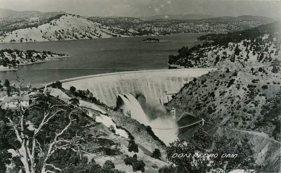
- Location: Tuolumne County, California
- Coordinates: 37.7415°N 120.3735°W
- Volume (acre-feet): 2,030,000
- Outflow: Tuolumne River
With a reserve of 2,030,000 acre-feet, the Don Pedro Reservoir is the sixth biggest in California (2.5 km3). It is located in the Sierra Nevada foothills of central California, about 90 miles (145 km) east of San Francisco.
The reservoir is used primarily for irrigation water supply and flood control, with recreational activities being a secondary use.
The dam was built between 1962 and 1977, mostly by the U.S. Bureau of Reclamation, although some funding came from the Central Valley Project Improvement Act of 1988.
It has a capacity of 2 million acre-feet (2.5 km3), which is around its design capacity of 2.15 million acre-feet (2.66 km3).
The dam and reservoir were built to provide water for the northern Sacramento Valley, including 29 water districts and cities throughout Northern California.
The lake is also used for flood control, hydroelectric power production, and recreation.
7. Lake Berryessa
- Location: Vaca Mountains, Napa County, California.
- Coordinates: 38.59°N 122.23°W
- Volume (acre-feet): 1,602,000
- Outflow: Putah Creek
Lake Berryessa is the seventh-largest reservoir in California, with a capacity of 1.6 million acre-feet (2 km3). It is located in Napa County, north of San Francisco.
The lake was created by the construction of Monticello Dam on Putah Creek in the early 1960s. The dam and reservoir were built to provide water for the Monticello Water District and other communities throughout Napa County.
The lake is also used for hydroelectric power production, flood control, and recreation.
Lake Berryessa is located east of the Napa Valley, between the Blue Ridge and Cedar Roughs, and offers year-round recreational activities.
In the summer, the water in Berryessa reaches temperatures of up to 75 degrees, making it perfect for water sports. Anglers enjoy fishing for rainbow trout, bass, catfish, crappie, and bluegill in both cold and warm water.
California’s Largest Reservoirs Are Vital Sources of Water
Each of these bodies of water has distinguishing qualities, such as its size and depth, the number of recreational options, and its capacity to produce water for a variety of purposes.
So whether you’re looking to take a dip on a hot day, catch some waves on your board, or simply enjoy the scenery, make sure to check out one of California’s amazing reservoirs.
And who knows, you might even get to see a few of the state’s iconic redwood trees while you’re at it!